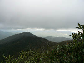
 The satellites are watching me make my way up a 45-degree incline, tracking a faint trace uphill from Fire’s Creek in the Nantahala Forest. It’s a cool, overcast day with the smell of rain in the air. I’ve driven all morning down from Asheville to Clay County, just north of the small town of Hayesville. There are plenty of trails closer to home, but I wanted to experience this short jaunt, to see for myself what this landscape’s first human inhabitants might have seen, to follow in the footsteps of ghosts and forgotten history. I’ve discovered this trail by happenstance, reading of the ancient Cherokee network of footpaths that crisscrossed the Southern Appalachians. Most of the major trading routes they followed have long since been paved over by modernity and asphalt. Where the tribe once walked, tourists and retirees zip along in SUVs and RVs. But a handful of the untouched, original trails remain, documented by the obsessive Cherokee pathfinder, Lamar Marshall of the Wild South preservation nonprofit. Marshall has made it his mission to travel these old ways. This morning, I’m traveling a 2.5-mile trail that rises some 2,000 feet from the roaring waters of Fires’ Creek to the surrounding ridges under Big Stamp, a former bald where deer and bison had bedded down on the grassy meadow centuries ago. Marshall’s description of the Cherokee trail seems accurate. This does go unerringly in a straight uphill line, unlike the switchbacks of later trails constructed for modern hikers. Cherokee trails were hated by the American armies who penetrated into their mountain kingdom. Their trails go straight up and down the mountains at perilous inclines that make horses balk and hauling wagons impossible. These were the fastest routes to the ridgetops before dropping down to the river towns where the Cherokee raised their children, grew their corn and danced in the ceremonies. This trail would likely have been a route over the ridges between the river towns of Tusquitte near modern-day Hayesville over to Tomatly, just north of Andrews. At half a mile, I’ve climbed about 800 feet, according to the GPS on my watch. The satellites orbiting hundreds of miles overhead watching me like an ant crawl up the mountainside. The trail itself tends to disappear in the leaf litter, a bare hint or suggestion running across roots and rocks. But this ancient route has been maintained. Blue blazes dot the trees above, rectangular plastic strips nailed to the trees every 50 feet or so, and crews have come through with chainsaws, clearing deadfall of previous winters. I follow my own spirit guides, my hiking companions today – Ben my faithful Golden Retriever and a new recruit Merlin, a rescue Poodle who’s about a year and half. Merlin stays by Ben’s side as they travel, Ben stopping ahead to make sure I’m not getting lost as I catch my breath. Ben stops to wallow in the dust, picking up a blazon on his right shoulder of some funky green shit, an irresistible spoor. There are signs of other animals who have followed this same path, scat - long ropy droppings of predators who’ve feasted on white and dark furred prey. Perhaps bear, maybe coyote. Another good sign. The Cherokee like indigenous people worldwide probably followed game trails. As I scramble uphill with labored breath and aching calves, the surrounding mountains come into view through the bare winter woods. At my back there is Brasstown Bald, down in Georgia, and I get glimpses of Lake Chatuge, the impoundment of the Hiwassee River, which flooded out old towns of the Cherokee and the white settlers who came later. There are no signs of civilization other than that diverted water. A jet drives unseen overhead, screeching across the sky, probably on a direct flight path out of Hartsville International 100 miles southwest in Atlanta. It is hard to escape our time and technology. The mountains keep their ancient shape, but the woods would have been different. The old-growth forests were clear-cut a century ago. And the chestnuts that made up a huge part of the hardwood died out with a blight brought from China. The younger growth is scragglier with more underbrush. There are blackened stumps and scorched trunks, signs of the massive wildfires that swept the Nantahalas during a fierce drought two years ago, another red-warning signal of the climate change that is reshaping our hospitable planet. Every landscape spells its own loss. The Cherokee of course were tragically uprooted from their homeland nearly two hundred years ago and forced to march west to Oklahoma along the Trail of Tears in one of our history’s darkest chapters. A few hardy survivors refused the journey, hiding out in the remote coves. These families would become the Eastern Band of Cherokee Indians. Traces of the Cherokee remain, their language merged with the landscape. Any map shows place names from the Cherokee or Tsalagi language: Watauga, Cowee, Cullasaja, Wayah Cartoogechaye, Hiwassee, Nantahala, the list goes on. I have a handful of Cherokee words I’ve learned, though I can’t really follow any fluent speaker. The language itself is more concrete and specific than English, with syntax placing us in time and space before settling on the individual speaker. I’ve learned from a native speaker Bullet Standingdeer who theorizes that the Tsalagi syllables and their piled-up order tell the listener where to physically look. Instead of placing the ego as subject first in your sentence, it’s a different way of walking through a welcoming world, Nogwo usdi nvnohi gega. Now the small road walking am I. Maybe I’ve been walking backwards in landscape in my language, the Cherokee offer a different worldview. After an hour and half, I step out of my meditative trance and into another century. The footpath is swallowed in the intersection with a former logging road, deeply and recently rutted with tire tracks of a heavy-duty four-wheel drive pickup, maybe bear hunters out scouting next year’s hunt. The ghosts are gone. They passed this way, but their footpath has disappeared. Likely they would have kept going over Big Stamp, headed down to the Nantahala River and the town of Tomatly maybe 10 miles below. My dogs splash happily ahead through the muck but wait for me ahead at an old campfire where hikers stopped on the 20 miles Rim Trail that circles the ridges above Fire’s Creek. I eat my turkey sandwich I packed this morning, saving the last bites for both Merlin and Ben, who’s wallowing in more mud and shit. They will need baths later when we get home. The rain that has held off starts a faint sprinkle. It’s time to go. Back home, I’ll download the GPS data from my watch via Bluetooth to my iPhone. The satellite imagery will show my red line like ant trail ending up through the green ridge, the imaginary colors of the map in a winter world showing a palate of grays and browns in reality. 4 hours , 2200 feet, the data shows. But now the trail travels into my muscle memory. I have taken the experience into my brain and bones. I can feel the earth beneath my feet, leaning into the rise, my hiking pole balancing me coming down through the trees, the mountains rolling away to the horizon all around, breathing in the place I feel most at home, outside of time and technology. Nogwo usdi nunohi gega. Now the small trail walking am I.
9 Comments
|
Dale NealNovelist, journalist, aficionado of all things Appalachian. Archives
April 2023
Categories
All
|
|
© Dale Neal 2012. All rights reserved.
|
Asheville NC Contact
|


 RSS Feed